From Positioning Errors to Weather Insights: An Introduction to GNSS Meteorology
GNSS Signal Delays and Atmospheric Information
Every time you glance at your smartphone to navigate a city street or check your car's "GPS", you are participating in a feat of modern geodesy. To determine your position with the centimeter-level accuracy we now take for granted, a satellite signal must traverse thousands of miles of the Earth’s atmosphere. Historically, this journey was a technical problem: atmospheric interference was "noise" that degraded positioning precision. However, in recent years, we have learned to stop squinting at this noise and start reading the signal. We have realized that the very delays that cause positioning errors are actually a high-fidelity probe of the atmosphere’s state. This paradigm shift has birthed the field of GNSS Meteorology, which defines satellite signal delays not as errors to be discarded. Signal delays that matter for positioning can also provide information useful for weather analysis and forecasting.
The Two Main Delay Sources: Ionosphere and Troposphere
GNSS (Global Navigation Satellite System) is the broader category that includes GPS (US), Galileo (EU), GLONASS (Russia), and BeiDou (China) satellites.
As GNSS signals travel to a ground receiver, two atmospheric regions introduce delay:
- Ionosphere: Delay in this layer is frequency-dependent because of charged particles. Multi-frequency combinations (for example using L1, L2, and L5 carrier-phase measurements) can largely remove ionospheric delay.
- Troposphere: Delay in the lower atmosphere is effectively frequency-independent for GNSS processing. It cannot be removed the same way, so it remains in geodetic solutions and is the main quantity of interest for meteorological use.
Tropospheric delay is often represented as Zenith Total Delay (ZTD), with two parts:
- Hydrostatic delay (ZHD): About 90% of ZTD, driven mainly by dry gases and pressure. It is relatively stable and can be modeled well from surface pressure.
- Wet delay (ZWD/SWD): Roughly 10% of ZTD, caused by water vapor. It changes quickly in space and time and is harder to model.
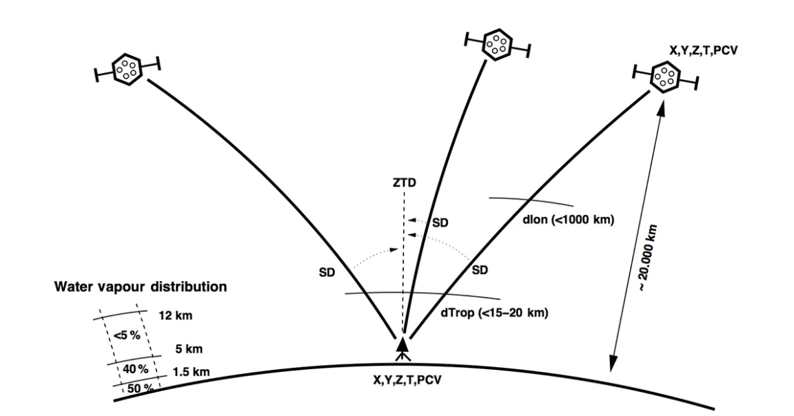 Schematic presentation of slant (SPD) and zenith (ZTD) time delays from three GNSS satellites (from Guerova et al 2016).
Although these are called "delays," they are expressed as length (excess path) rather than time.
Water Vapor Estimation (PWV)
Water vapor is a key variable in atmospheric thermodynamics and storm development, but it is difficult to measure continuously with high temporal resolution. In the grand theater of our climate, water vapor is the "engine." It stores and releases latent heat, playing a fundamental role in the global energy balance and the formation of storms. Yet, as noted in Matakos (2024), it remains the "hardest fundamental meteorological parameter to measure and predict". Using GNSS signals we can transform the Slant Wet Delay (SWD)—the raw delay measured along the specific line-of-sight between a satellite and receiver—into Precipitable Water Vapor (PWV). This represents the total moisture content in a vertical atmospheric column over the site under observation.
Short-Term Storm Monitoring: PWV Increase Before Convection
Thunderstorm development typically depends on moisture, instability, and lift (for example, from fronts or local convergence). Conventional monitoring uses tools like radiosondes and satellite products.
GNSS adds near-continuous temporal coverage (often minute-level) and allows us to observe the "PWV Jump." In the lead-up to a storm, rapid evaporation conveys an abundance of moisture into the troposphere, which then raises PWV values significantly in a very short window. A classic case study occurred during the CHUVA Vale field campaign in Brazil (November and December 2011). GNSS data revealed a sharp spike in PWV levels, observed in the 2 hr period before a heavy storm that occurred during day of year (DoY) 341 (December 7, 2011, 1836 UTC).
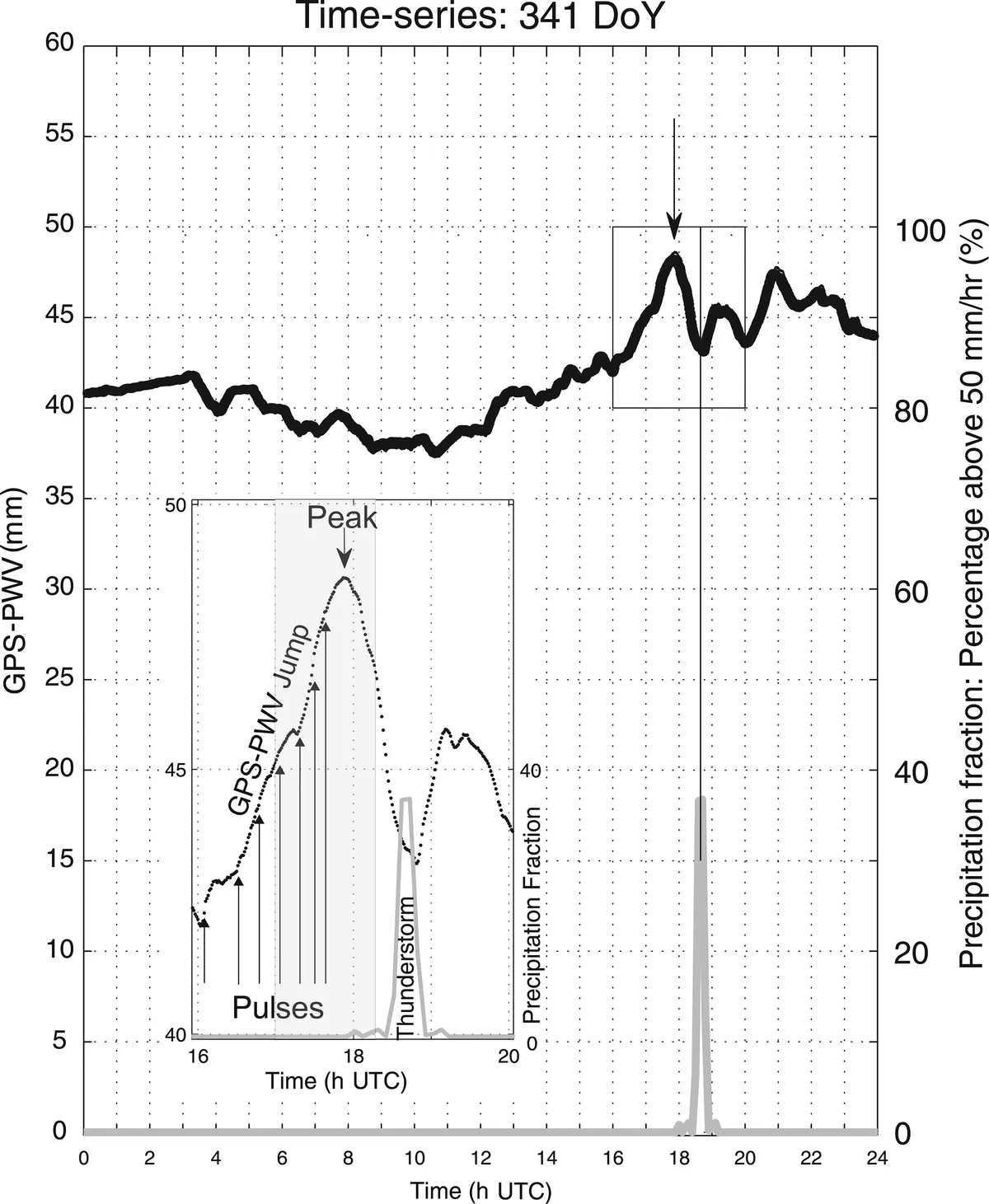 PWV increase before a storm (from Sapucci et al., 2018).
References
- Bevis, M., et al. (1992). GPS Meteorology: Remote Sensing of Atmospheric Water Vapor Using the Global Positioning System. Journal of Geophysical Research.
- Chu, Y., et al. (2022). Deep Learning for GNSS-Derived Water Vapor. Remote Sensing Applications.
- Matakos, A. (2024). Deep Learning Enhanced GNSS Tomography. Master’s Thesis, University of Helsinki.
- Torcasio, M. E., et al. (2023). GNSS-Based Water Vapor Monitoring and Nowcasting. Atmospheric Research.
- TRYAT (2019). Thunderstorm formation: What do the GNSS Precipitable Water Vapor (PWV) data say? [Online Video Transcript].