Climate Risk Assessment
Years ago, when I was a member of a reading group on "lab literature", I came across the novel "Odds against tomorrow", by Nathaniel Rich. In this novel, the main protagonist is a nerdy mathematician (Mitchell Zukor) who is exceptionally good at making predictions and calculating the cost of disasters. He goes to work at a financial consulting firm called FutureWorld after a major earthquake destroys Seattle. Zukor develops cost assessment of natural disasters, ecological collapses, financial crises, wars, etc, but the main focus of his work is climate-change risks. In fact, the novel has been named "the first great climate-change novel".
I enjoyed the novel, but it came to the scientific realism of the methods I found the novel fell a bit short. For example, the protagonist goes through technical reports and printed tables as well making graphs by hand. I can't remember how accessible open weather/climate data was back in 2012/2013, but I do remember thinking at the time: "no scientist will be making plot by hands or reading decades of data from printed tables".
As an atmospheric scientist, I work at the intersection of weather and climate, with a focus on data analysis and the development of short term forecasts and long term climate projections. When I want to see the effects of climate change in real time my first approach would be to have a look at the most up to date reanalysis --a comprehensive reconstruction of past climate conditions that integrate observational data with numerical weather models. In practice this means accessing something like ERA5 data via the Copernicus Data System CDS or any of the multiple sources of this data available online.
Modern reanalyses
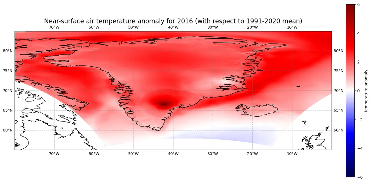
Part of my work involves contributing to the production of reanalyses (usually nested in ERA5 data). One example is the Copernicus Arctic Reanalysis project CARRA. My participation in this project has given me a direct and real-time view of the accelerated warming on arctic areas. As part of an online training on CARRA, I made the figure below, that shows surface temperature anomalies (see the jupyter notebook here for details), using data from the CARRA dataset. If anyone is interested in listening to other examples of CARRA data, check out this list of videos in youtube (one of them contributed by yours truly).
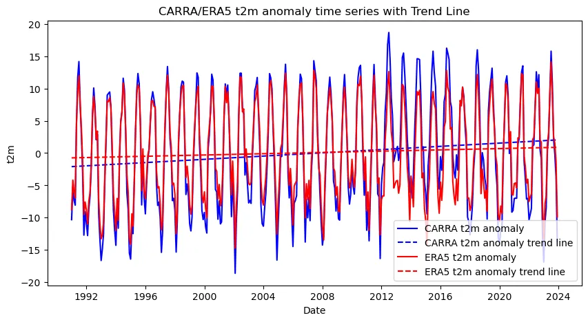
One of the great advantages of using a high resolution reanalyses is that it allows to see more details missed by coarser resolution reanlyses. Below is a comparison of 2 meters temperature for CARRA (2.5 km resolution) and ERA5 (31 km resolution).
Open tools and data for climate risk assessment
Although I don't work directly in climate risk assessment, my professional involvement with weather and climate data has naturally led to a personal fascination with how this information translates into real-world risk evaluation. This curiosity has recently motivated me to research the tools and datasets used by companies in this field. As starting point, climate risk assessment falls into the purview of Extreme Event Attribution (EEA) and Catastrophe Modelling (or cat modelling).
Climate risk assessment has multiple applications, including finance, insurance, urban planning, and disaster risk management. Given its multidisciplinarity and broad range of applications, it must require multiple data sources and modeling assumptions. As noted in this Aon article, climate risk models are essentially "a blend of the Global Climate Model output and a cat models, which includes a financial engine." They acknowledge coming "with a high level of uncertainty" but are designed to help companies make strategic decisions.
As highlighted in this Medium article by Lin Zhu, the proliferation of open-source platforms and datasets has democratized access to climate information.
Below is a list of the open data sets that can be used in assessing climate risks.
The Copernicus Data System (CDS), gives access to the most up-to-date reanalyses data sets.
Wekeo is another data source of Copernicus data, as well as sentinnel data.
In terms of open platforms and open source software is worth mentioninng
- CLIMADA, developed by ETH Zurich, an open-source platform for probabilistic risk modeling of weather and climate hazards. It integrates hazard, exposure, and vulnerability data to estimate potential impacts and inform adaptation strategies.
- A very comprehensive list of models and data sources can be found in The Open Data for Climate Change initiative
While Nathaniel Rich's protagonist Mitchell Zukor was limited to hand-drawn graphs and printed tables, today's climate risk analysts have unprecedented access to real-time, high-resolution data and sophisticated modeling platforms. The democratization of climate data through initiatives like Copernicus and open-source tools like CLIMADA means that the kind of comprehensive risk assessment Zukor performed is now accessible not just to major consulting firms, but to researchers, smaller organizations, and even individuals worldwide. This transformation represents both an opportunity and a responsibility—as the tools become more accessible, the need for scientific literacy and proper interpretation of climate data becomes ever more critical.